
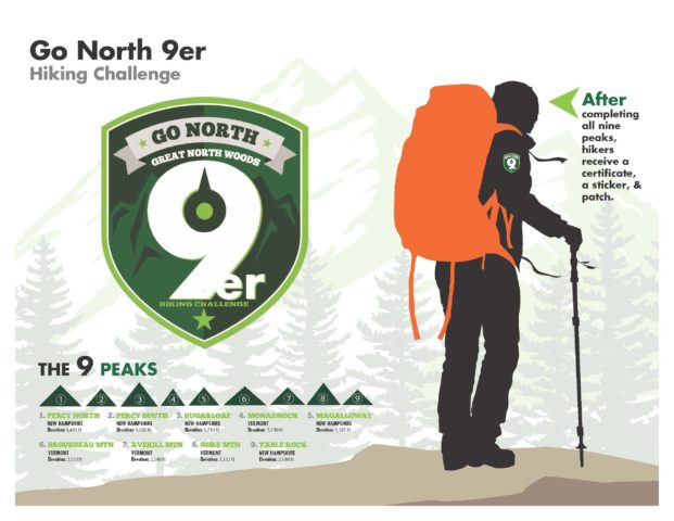
There’s an adventurous spirit in all of us. In the Great North Woods, you can answer that call by becoming a Go North 9er. Rise to the challenge and become an official “Go North 9er” by climbing all nine peaks beginning May 1, 2020. Start by completing the online registration form below, and start the hiking challenge!
For those who do have the legs, lungs and heart to complete all nine of the Go North 9ers, you will receive a certificate with an official member number, all numbers are awarded in the order of completion, and a custom 9er patch to let everyone know you conquered the famed peaks. Your name will also be added to the official Go North 9er member roster. Make sure to take a photo of yourself at the summit of each of the 9ers.


Where to begin your hiking challenge?
The 9ers are a great introduction to hiking in the Great North Woods. Along the way, you’ll find rewards aplenty: gently rolling terrain, bird-filled wetlands, towering pine forests and steep challenging ascents that lead to outstanding views of mountains and water. Keep in mind some of the hikes are on gated roads and those gates are closed until Memorial Day weekend typically so you’ll want to do your research before you set out.
Not all 9ers are created equal, which can make it difficult to know where to begin. Start by hiking Table Rock or Brousseau Mountain — they’re the easiest of the peaks and particularly good for people hiking with kids. Work your way up to the more difficult climbs, where higher elevations reward hikers with more expansive views. Once you’ve completed all nine you’ve earned bragging rights — and a 9er patch!
Hiking Tip:
We encourage all hikers to get a Hike Safe Card, which is only valid in New Hampshire, is sold and administered through the NH Fish & Game website. ALL QUESTIONS ABOUT THE CARD should be directed to NH Fish & Game at 603-271-3421 or info@wildlife.nh.gov. Buy a Hike Safe Card.
Leave No Trace
The magic of the Great North Woods is the result of previous generations taking a long view and protecting the mountains, lakes and rivers within the North Country. That tradition continues today as we support and encourage everyone to practice Leave No Trace ethics, which help protect the lands and waters of the Great North Woods.
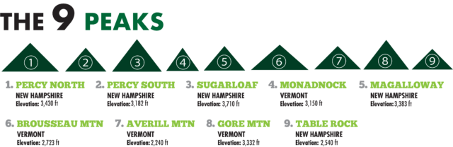
North & South Percy: North Percy Trail is a 3.8 mile lightly trafficked out-and-back trail located near North Stratford, New Hampshire that features a great forest setting and is rated as difficult. The trail is primarily used for hiking and is best used from May until October. The Cohos Trail Association built or restored a number of trails on the conspicuous and steep Percy Peaks in the Nash Stream Forest north of the White Mountains. You can make a half-day loop hike to both North and South Percy Peak summits by following the Percy Loop Trail to the upper end of the Percy Peaks Trail. The Percy Loop Trailhead is 1.2 miles beyond the Percy Peaks Trailhead, on the right, and is signed. Parking is on the left next to a driveway to a camp. Be sure not to block the driveway.
Sugarloaf Mountain: This trail is a 4.4 mile lightly trafficked out-and-back trail located near North Stratford, New Hampshire that features a great forest setting and is rated as difficult. The trail is primarily used for hiking and nature trips and is best used from May until October.
Directions: From Colebrook take Route 3 South to Groveton, N.H., take a left off of Route 3 to get onto Route 110 East. After 2.6 miles on Route 110, take a left onto Emerson Road. Follow this road for 2.2 miles until the road makes a sharp right-hand turn. At this point, turn left onto Nash Stream Road and follow it for 8.1 miles to a small, signed parking area on the right.
Monadnock Mountain: This trail is currently CLOSED please use Middle Mountain (ALTERNATE HIKE). Begins moderately through a small meadow and continues into a young forest following a scenic brook, long log bridge, and rocky ledges. From there, the trail begins its persistent steep climb upward over the rocky footing. At the summit, 3,150 feet, all that remains of the burned fire warden’s cabin is the chimney and foundation; but the fire tower is still functional and provides panoramic views of the Connecticut River Valley as well as Vermont’s Green Mountains and New Hampshire’s White Mountain Range. This trail is about 2.3 miles one way, fit for moderate and advanced hiking enthusiasts.
The trailhead and parking can be found on Route 102, Vt. Take Bridge Street in Colebrook, follow to the end. Take left at the stop sign and there is a pull-off on the left-hand side of the road. Hikers can park there. About a two-hour hike, the old fire tower is situated atop the mountain allowing one to view two states.
ALTERNATE HIKE – Middle Mountain: This trail combines numerous logging trails, game paths, and new segments to explore the deeper forests of the Northeast Kingdom. This trail passes through private property, so please respect the landowner and protect future access by staying on the marked trail and following all rules.
This trail starts at VT-114 using portions of the historic Unknown Pond Trail and climbing out of the valley along the ‘south arm’ of Middle Mountain. The trail starts on Unknown Pond Trail, then in 1.3 miles becomes Middle Mountain Trail. It continues to climb to the summit of Middle Mountain (2,949 ft), from which hikers can continue on the trail to descend the north side of the mountain and join with the Gore Mountain Trail.
Directions: Take Route 3 north to West Stewartstown and take a left onto VT Rt. 114S. Continue on VT 114S for 22.1 miles. You will pass Norton Pond on your right. The parking and trailhead will be on your left. If you pass Hurricane Brook Road you’ve just passed it.
Mount Magalloway: A climb up Magalloway can be done as a loop hike of just over two miles. On the summit, hikers can access a fire tower, look down at miles of the region’s unspoiled wilderness and enjoy views extending into Vermont, Maine and Quebec. Two well-marked trails lead to Magalloway’s summit – Coot Trail and Bobcat Trail – and together they form an enjoyable loop hike.
The trailhead is located in Pittsburg. Take Route 3 past 1st Connecticut Lake- take a right onto the Magalloway Road. Stay straight on this dirt road until you see the “fire tower” signs and take a hard right. Follow this road to the end of a grassy parking area. Caution: This is the main logging road and logging trucks have the right of way. It’s just a 40-minute hike before you can climb the fire tower and are able to take in four counties and breathtaking views. 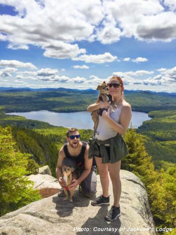
Brousseau Mountain: Brousseau Mountain in Vermont is a short but beautiful hike. This is many people’s favorite hike. At 2,723 feet, it’s not the tallest mountain in the area, and depending on your hiking level, it can take anywhere from 30-45 minutes to reach the top. The difficulty is easy to moderate. The 0.7 mile one-way trail leads into a recently-cut forest, transitioning from deciduous to balsam fir forested peak with some points traversing wooden planks, and others that are granite bedrock inclines.
Directions: Go west on Route 114 in Averill, Vt., 1.5 miles from Lake View Store. Take a left onto Mountain Road. 1.3 miles down Mountain Road there is a dead-end gate. Turn your car around so you don’t block anything. About 35 minutes to the top on a well-marked trail. At this point there is no view. Take another trail to the right, this leads to a lookout point, about two minutes away. This provides a wide panorama view of the White and Green Mountain ranges. Wildlife is also part of the view.
Averill Mountain: Averill Mountain in Vermont is a short, scenic, rewarding hike to a height of 2,240 feet. At just under 3/4 of a mile, this is considered an easy to moderate hike. The view from the top is definitely worth the climb. Once at the top, it levels out on a large rock outcropping overlooking Big Averill Lake.
Directions: 15.2 miles from the Rest Area on Route 3. Take Route 3 north to West Stewartstown and take a left onto VT Route114S. Proceed to the Averill Lake View Store, 0.5 miles from the store is a small white sign for Averill Mountain. The mountain has a gradual ascent with a vertical rise of 550 feet from the trail’s starting point. The trail is very well marked and upon reaching the summit, hikers can see Table Rock in Dixville, N.H., Mt. Washington and Jay Peak.
Gore Mountain: Vermont’s Gore Mountain is by far one of the larger mountains in the area and is not recommended for beginner hikers. Reaching an elevation of 3,332 feet, this 4-mile one-way hike can take upwards of a few hours.
Directions: 30.3 miles from the Rest Area on Route 3, take Route 3 north to West Stewartstown and take a left onto VT Rt. 114S. Continue through the village of Norton for another 9.9 miles. Look for Lake Station Road at the north end of Norton Pond and pull off between that and Devost Road. The trail enters through a small opening on the east side of the road. The hike includes a series of beaver meadows, crossing several brooks and hiking through the edge of an expansive logged-off area. From the summit, there are limited views of the Nulhegan Basin. The length of the trail to the summit is 3.9 miles.
Table Rock: This stark 2,540 foot protruding cliff is formed of vertical slabs. It is less than 10 feet wide at its narrowest point. The vertical drop from table rock is 700 feet. Use caution! The view is spectacular!
Directions to Table Rock are: Take Route 26 east from Colebrook about 10 miles. The trail originates on Route 26, 0.2 miles east of the junction of the access road to The Balsams/Wilderness Ski Area and Route 26. Park off the road in the clearing on the right. This trailhead is marked with a red Table 50 sign. This the safest way to climb up! For a more difficult climb – drive past the aforementioned parking area. Drive passed the Balsams Wilderness Resort (on your left) and park in the small gravel area on the right (just prior to reaching the top of Dixville Notch). This trail, Table 52, ascends almost vertically from the parking area. It is steep and rocky and should not be attempted when wet.
Winter Hiking
Averill Mountain, Brousseau Mountain, and Table Rock (Table 50) are accessible in the winter months. Please make sure to use proper equipment while hiking in the winter. All other 9er hikes are not easily accessible during the winter months.
Instructions
Eligibility for program entry shall be limited to people who have climbed and descended the summits of the 9 Great North Woods peaks. All 9 peaks must be climbed on or after the registration date. Make sure to take a photo of yourself at the summit.
Once the North Country Chamber of Commerce receives the completed information, each finisher will be sent a certificate with an official member number, a 9er patch, and a 9er sticker. Your name will be added to the member roster.